
Smart GIS mapping tool
We’re gaining international attention for a smart mapping tool we developed that gives a layered view of what’s happening across our vast electricity network.
Using Esri ArcGIS, the geospatial tool helps us effectively plan what assets need to be replaced, ensuring we continue to be prudent asset managers – repairing or replacing the right equipment at the right time, in the right locations.
Applying geospatial science and technology to our work as a multi-infrastructure owner-operator, has seen our team present virtually and physically across the globe. This includes at the 2023 IMGIS Infrastructure Management and GIS Conference in the United States.
Representing Powerco on the stage was our Senior Solutions Specialist David Haberkorn and Overhead Assets Fleet Manager Ken Pattie.
Why we use this technology
We required a smart tool to identify and prioritise which overhead power assets needed replacing and when. That’s because, working out whether or not to renew a line and other equipment, such as crossarms, poles and fuses, is only loosely related to the age of the asset. It also depends on factors such as:
- The type of the material
- The environment it’s in
- Visual assessments of condition
- Past construction practices
- Manufacturing defects
- Fault history
Previously, all this information was kept in various spreadsheets, which can be tricky to cross reference easily. Instead, the overhead renewal planning tool allows us to view what was previously hidden in data from multiple sources and use it to make our network not only safer, but more reliable.
New information about our electricity network is constantly being added to the tool to inform our decision making and planning.
How we use it
The smart mapping tool divides the network into hexagons on a map. It then assigns a score to each hexagon, based on weighted calculations which include:
- Age of assets
- Past faults
- Condition of assets as a score
- Known problem asset types
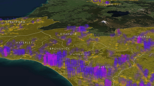
The resulting scores enable the visualisation of the network condition as a heat map.
The heat maps give us a large-scale overview, highlighting hot spots (see image below) where there are assets with many defects. This guides our engineers to where there were potential project areas.
Viewable layers include assets (wires, poles, transformers), faults, conditions, asset health, and environmental factors. It’s also the tool we use to plot vehicle vs pole incidents in an effort to design safer public roads.
It means we can also see what had been previously unseen, including the number of customers potentially affected by equipment failure, as well as risk, allowing our planners to see where investment will provide the most benefit.
Read the Powerco case study on Esri’s website here.